HoudahGeo是一款使用的程序,将帮助解决地理照片纬度,经度和高度的编码信息。
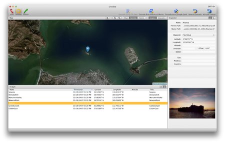
HoudahGeo “pins” photos to locations where they were taken. Professional grade processing. Mac ease of use. Just like an expensive GPS camera, HoudahGeo can store latitude, longitude and altitude information right within the image file – invisibly with no loss of quality. HoudahGeo writes EXIF, XMP and IPTC tags. HoudahGeo projects may be published to EveryTrail or viewed and shared using Google Earth. Geotagged photos may be saved to Evernote or uploaded to Flickr or locr.
System Requirements
HoudahGeo requires Mac OS X 10.6 Snow Leopard.
It is fully compatible with Mac OS X 10.8 Mountain Lion.
Home Page: http://www.houdah.com/houdahGeo/index.html
Download freakshare
http://freakshare.com/files/skpp3uoe/HoGeo.3.4.4.zip.html
Download filefactory
http://www.filefactory.com/file/73zobfl6b5oj/HoGeo.3.4.4.zip
Download uploaded
http://ul.to/25gicuub
Download 城通网盘
http://www.400gb.com/file/23224036
Download 百度云
http://pan.baidu.com/share/link?shareid=419279557&uk=909160512
转载请注明:0daytown » HoudahGeo 3.4.4 Mac Os X